MEDIN is delivering data through a network of accredited Data Archive Centres
British Oceanographic Data Centre
The British Oceanographic Data Centre (BODC), part of the National Oceanography Centre, is a national facility for storing and distributing data concerning the marine environment. The BODC also provide services supporting digital infrastructure and the FAIR data principles, such as DOIs and the NERC Vocabulary Service (NVS). The BODC has been accredited as a MEDIN Data Archive Centre for water column oceanographic data since 2009, was re-accredited in 2017 and achieved CoreTrustSeal accreditation in 2023. The BODC Origins and experience date back to 1969 with the creation of the British Oceanographic Data Service (BODS). The BODC are part of the Intergovernmental Oceanographic Commission’s network of data centres, providing a resource for science, education and industry, as well as the wider public.
DATA ACCESSIBILITY
The goal is to provide direct access and online delivery to all data holdings. The BODC data applications give direct access and online delivery to over 146,000 data series through its National Oceanographic Data Base – NODB and over 5.5 million discrete water bottle samples of chemical, biological and physical parameters. The NODB offers: anonymous searching, ‘online shopping’ with basket and checkout, various data formats, secure access control, user request tracking, auto-download.
BODC Datasets are available on the MEDIN portal. If you can’t find what you are looking for, please contact enquiries@bodc.ac.uk.
![]()
![]()
British Geological Survey
The geology, geophysics and backscatter DAC is operated by the British Geological Survey (BGS) and stores seabed and sub-seabed geological and geophysical data covering the UK Continental Shelf (UKCS) area and also deals with the backscatter component of bathymetric data. BGS was accredited MEDIN DAC status in 2009, and was re-accredited in 2017.
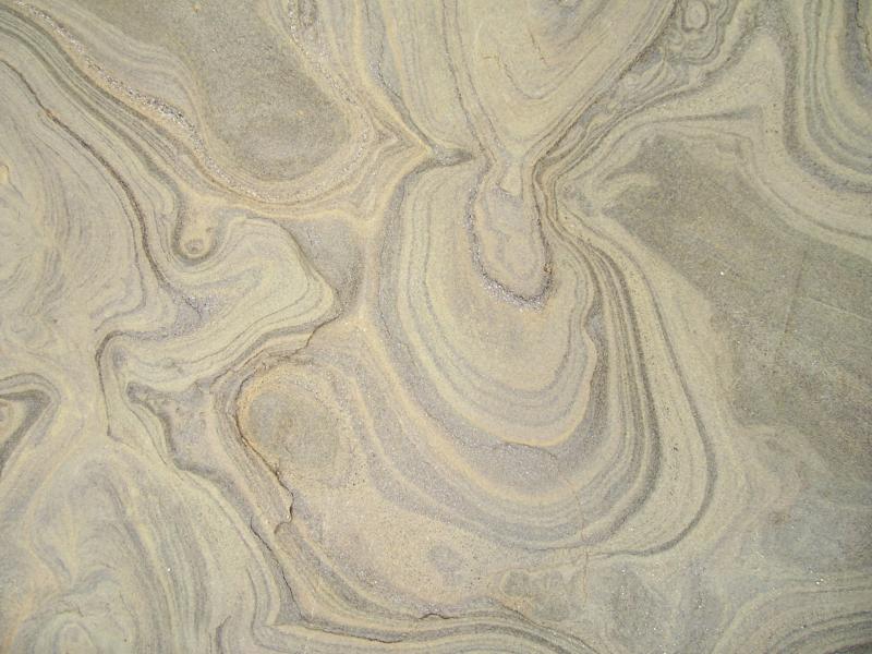 Photo: British Geological Survey
 Photo: British Geological Survey
Founded in 1835, the British Geological Survey is one of the oldest national geological survey organisations in the world. BGS is a public sector organisation responsible for advising the UK government on all aspects of geoscience as well as providing impartial advice to industry, academia and the public. BGS hosts the National Geoscience Data Centre (NGDC) and within this manages UK marine geoscience data in the MEDIN DAC.
Data Types:
-
Seabed sample data from grabs and cores including:
- Geological descriptions
- Geotechnical
- Geochemical
- Particle Size Analysis
- Geophysical data including – Sidescan sonar, backscatter and shallow seismic
- Physical materials (Cores and samples)
- Records
- Maps
- Documents
DATA USE
Data are used by public, commercial and academic organisations for a wide variety of applications. Examples include sea-bed mapping, site investigation, environmental impact assessment, resources, renewable energy, aggregates, aquaculture and fishing, conservation, and archaeology.
DATA ACCESS
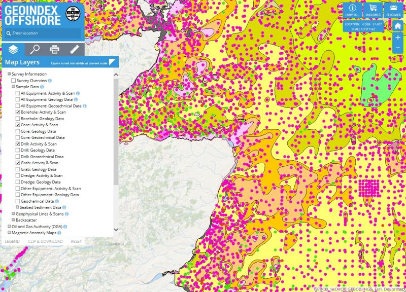
- Access data using the BGS Offshore GeoIndex (also available as a web map service ).
- Data is also available via our OGCAPI-Features server
- Strategic Environmental Assessment (SEA) data can be accessed via a separate SEA portal.
- Data can also be accessed via the MEDIN portal – marine datasets, marine survey datasets, SEA datasets.
If you can’t find what you’re looking for, please contact BGS.
SUBMIT DATA
Submit data through the NGDC Data Deposit portal.
For complex, large volume or recurrent datasets, please contact BGS. Depending on the volume, type, and quality, BGS may quote a cost for archiving the data.
For further details, see our data submission guidelines.
British Geological Survey
The Lyell Centre
Research Avenue South
Edinburgh
EH14 4AP
Telephone: +44 (0)131 667 1000
Email: offshoredata@bgs.ac.uk
DASSH
DASSH is the MEDIN DAC for marine species and habitats data and was accredited in 2009. Covering all aspects of marine biodiversity, from seabirds to plankton and the related marine habitats, DASSH is committed to supporting the FAIR principles for open data and open science.
DASSH is a flagship initiative of the Marine Biological Association (MBA), and builds on the MBA’s historic role in the promotion of marine science. Through partnerships with other UK and European data centres DASSH contributes to both national and international data portals including the NBN Atlas, EMODnet, EurOBIS and GBIF.
DATA TYPES
DASSH collects, manages, archives and publishes data (electronic and physical) and images collected (or collated) by a variety of public and private organizations who undertake biological surveys. DASSH holds data and images from both volunteer and professional surveyors in order to provide a data management and archive service. This service is available to data providers who wish to outsource their data management, ensure legislative compliance or who do not have the facilities to ensure the long-term security of their data.
The survey types held vary from one-off surveys or observations, to long-term time series, and monitoring programme data. Species data includes records of marine fauna and flora, while habitat data include biotope or assemblage data.
DATA USE
Data are used by public, commercial and academic organisations for a wide variety of applications. Examples include, informing the designation and monitoring of Marine Conservation Zones, the identification of priority areas for protection and management. DASSH routinely responds to specific queries from research scientists, consultancies and government agencies.
DATA ACCESSIBILITY
DASSH holds datasets provided by a variety of public and private bodies, and individual researchers. The Data/image provider (and Copyright holder if different) will be stated in the associated metadata. Data providers retain the copyright of the original data or images at all times. Data providers have given DASSH their permission to hold a copy of their data/image(s) within the data archive.
DASSH is committed to open and FAIR data, and so promotes the use of license models that support this approach. All our data and image holdings are made available for use under the most appropriate data license, as agreed with the Data Provider.
Standardised data held are made available through the DASSH online search tool.
Datasets are available from DASSH on the MEDIN portal.
CONTACT
Telephone: +44 (0)1752 426237
Email: dassh.enquiries@mba.ac.uk
![]()
![]()
Cefas, Marine Directorate of the Scottish Government, DASSH
Centre for Environment, Fisheries and Aquaculture Science (Cefas) and the science team at the Marine Directorate of the Scottish Government have been accredited as a MEDIN FishDAC since 2012 and were successfully re-accredited in 2018. Accreditation has lapsed but they may apply for Core Trust Seal in the future.
The FishDAC is the combined MEDIN Data Archive Centre for fish, shellfish, fisheries and related samples data. Third-party data, including that of the Inshore Fisheries and Conservation Authorities (IFCAs) is managed by DASSH.
DATA ACCESSIBILITY
FishDAC data are available from the MEDIN portal.
CONTACT
UK Fisheries:
Cefas
Email: data.manager@cefas.co.uk
Marine Directorate of the Scottish Government
Email: marinescotland@gov.scot
DASSH
Telephone: +44 (0)1752 426237
Email: dassh.enquiries@mba.ac.uk
Historic Environment DACs
The MEDIN DAC for historic environment data. The Archaeology Data Service (ADS), Historic Environment Scotland (HES) and the Royal Commission on the Ancient and Historical Monuments of Wales (RCAHMW) are a combined DAC for the marine historic environment data. Originally accredited as a MEDIN DAC in 2012 and recently re-accredited in June 2016. ADS supports research, learning and teaching with freely available, high-quality, dependable digital resources. It does this by promoting and disseminating a broad range of digital data in archaeology and preserving it for the long term. The ADS promotes good practice in the use of digital data in archaeology, provides technical advice to the research community and supports the deployment of digital technologies.
Archaeology Data Service (ADS)

![]()
The Archaeology Data Service supports research, learning and teaching with freely available, high-quality, dependable digital resources. The ADS promotes and disseminates a broad range of digital data in archaeology and preserving it for the long term. The ADS promotes good practice in the use of digital data in archaeology, provides technical advice to the research community and supports the deployment of digital technologies.
DATA TYPES
- Palaeolithic to present day digital data fror archaeology
- No limitations on collections of data
DATA USE
All data disseminated by the ADS is available to access openly and free from charge for its users. Conditions under which data can be reused depends upon the licence attached to a particular data collection by the data depositor. The access licence of a dataset is clearly identified on each data collection page. The Archaeology Data Service (ADS) levies no charge to use its collections when used according to these terms.
DATA ACCESSIBILITY
All data held and archived by the ADS is available through the website. This data is available through ArchSearch, an integrated online catalogue indexing over 1.3 million metadata records, including ADS collections and metadata harvested from UK historic environment inventories. ArchSearch records briefly describe archaeological events, monuments or sites, and may link to the resource the information was harvested from. The archives themselves are classified into a number of cateogories such as subject, programme and region. By using the faceted classification system, a user can constrain the archive search. The results themselves can then be ordered alphabetically by title of chronologically on the year of their release.
CONTACT
Telephone: +44 (0)1904 323954
Email: help@archaeologydataservice.ac.uk
Historic Environment Scotland (HES)
![]()
Historic Environment Scotland encourages people to value and enjoy their surroundings, to provide a world-class record of the historic and built environment to local, national and international audiences, as well as advancing understanding of the human influence on Scotland’s places from earliest times to the present day.
DATA ACCESSIBILITY
Data deposited with Historic Environment Scotland follows an accessions procedure. Once catalogued, our digital holdings are available online through the Canmore database. Canmore combines location information, site details and digital archive material including digital images on more than 320,000 archaeological, architectural, maritime and industrial sites throughout Scotland in a searchable database and web map browser. Information from Canmore is also published on PastMap and provided to the National Marine Plan Interactive portal.
DATA USE
Data created by Historic Environment Scotland is Crown Copyright. Some data, including pdfs, may be downloaded from Canmore. However, digital images, photographs, copies of drawings, photocopies and lasercopies, GIS and database downloads and reports may be requested online and can be supplied for a small fee. A quote is always supplied on order requests with no commitment to purchase.
The source and copyright of any data you use should be acknowledged. Data must not be sold or supplied to a third party.
CONTACT
Telephone: +44 (0)131 651 6872
Email: archives@hes.scot
Royal Commission on the Ancient and Historical Monuments of Wales (RCAHMW)
The Royal Commission on the Ancient and Historical Monuments of Wales has a leading national role in developing and promoting understanding of the archaeological, built, and maritime heritage of Wales, as the originator, curator and supplier of authoritative information for individual, corporate and governmental decision makers, researchers, and the general public.
The landscape and built heritage of Wales result from people’s interaction with the natural world over thousands of years. Since it was established in 1908, the Royal Commission has led the way in researching and explaining the remains of that interaction – the archaeology and the historic buildings we see around us.
In addition to the extensive site database which comprises the national record of the historic environment in Wales and numbers over 119,000 entries, the Royal Commission holds a unique collection of photographs, maps, images, datasets and reports within its archive, the National Monuments Record of Wales (NMRW). Both the site database and archive contain records relating to the marine environment, including shipwrecks, submerged landscapes and coastal features; and the NMRW includes archives and datasets from maritime recording and archaeological survey.
DATA ACCESSIBILITY
The information held by RCAHMW is made freely available under the Government Non-commercial License, and can be accessed in multiple ways. Through Coflein, our online site database and catalogue, which allows users to search our site database and related catalogue of archive collections; via the People’s Collection Wales website and the Historic Wales Portal, which allow our records to be viewed alongside those of other bodies in the heritage sector in Wales; or by accessing the NMRW directly in our public search room and through our public enquiries service. We also engage with our audience through our publications, exhibitions, and a host of other activities.
CONTACT
Telephone: +44 (0)1970 621200
Email: nmr.wales@rcahmw.gov.uk
![]()
Met Office
The Met Office stores meteorological data and has been an accredited Data Archive Centre (DAC) for MEDIN since 2011 and was re-accredited in 2018. The Met Office is active within the international marine meteorological community and plays an active role in World Meteorological Organisation programs for sharing and developing marine meteorological data and processes.
The Met Office is the DAC for marine meteorological (metocean) data and was established in 1854 as a small department within the Board of Trade and now, more than 150 years on, is the UK’s National Weather Service. In addition to weather forecasting, the Met Office’s Hadley Centre is one the world’s leading climate research centres. The Met Office operates as a Trading Fund within the government’s Department for Science, Innovation and Technology (DSIT) and is required to meet targets as set by its Ministerial Owner.
Within the area of marine data the Met Office maintains a network of instrumented moored buoys and systems on light vessels, manages a fleet of around 200 Voluntary Observing Ships (some with automated systems on-board), manages the UK Argo programme and deploys drifting buoys in support of the European (E-SURFMAR) and international global drifter programme. The Met Office is active within the international World Meteorological Organisation (WMO) marine programs and DAC staff participate in WMO Task Teams for aspects of Marine Meteorology.
The Met Office Oracle climate database (MIDAS) currently contains over 230 million marine meteorological observations from ships, moored buoys, light vessels, coastal systems and rigs/platforms dating back to 1854 up to the present. Data received over the WMO Global Telecommunications System (GTS) are ingested daily, adding around 36,000 observations per day.
In addition the Hadley Centre maintain a number of key global marine climate datasets including: HadISST – Globally complete sea-ice and sea-surface temperature; HadSST4 – Uninterpolated sea-surface temperature; HadNMAT2 – Uninterpolated night marine air temperature; EN4 – Sub-surface temperature and salinity profiles and analyses; HadIOD – Surface and sub-surface temperature and salinity observations.
Also, a wide range of Met Office ocean model datasets (including the high resolution OSTIA global SST products) are made available via the Met Office Website as well as the Copernicus Marine Service.
DATA ACCESSIBILITY
All ship and buoy data are exchanged internationally via the WMO GTS and are available through the International Comprehensive Ocean Atmosphere DataSet (ICOADS).
Real-time data (previous 24 hours) from the Met Office moored buoys, light vessels and coastal stations around the UK are available via the Met Office website.
All UK Argo float data are archived by BODC and are available through the two Global Argo Data Assembly Centres (GDACS) in France (Coriolis) and USGODAE.
The Met Office Hadley Centre Global maintains marine climate datasets, which are available for download free of charge for scientific research and private study.
Most data are publicly available although some third party datasets may require approval from the original data owner before data can be released. A charge may apply to cover distribution costs and any additional work required. See the Met Office terms of use.
DATA USE
Marine meteorological data from the Met Office is utilised by a diverse range of users including public, commercial and academic organisations for a wide variety of applications. Examples include climate research, legal cases, ship builders, renewable energy companies, university projects, etc.
CONTACT
Telephone: +44 (0)370 900 0100
Email: enquiries@metoffice.gov.uk

United Kingdom Hydrographic Office
The UK Hydrographic Office (UKHO) is the accredited MEDIN Data Archive Centre for bathymetric data. The UKHO stores, processes and disseminates bathymetric data gathered around the British Isles.
All UK Government sponsored survey data gathered in support of charting (Civil Hydrography Programme data) around the British Isles is held and made accessible.
Data sets supplied by other government survey organisations are also held and made accessible where possible along with data sets gathered by Port Authorities, environmental organisations and academic institutes.
 Photo: UK Hydrographic Office
 Photo: UK Hydrographic Office
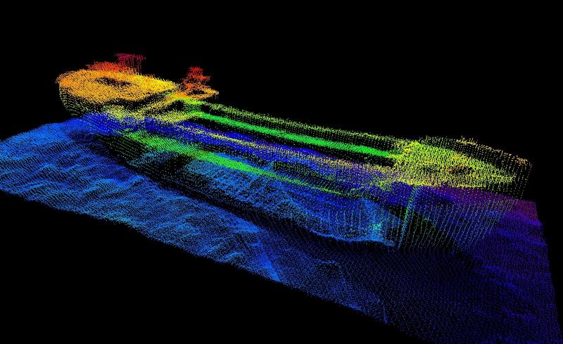 Photo: UK Hydrographic Office
DATA USE
The bathymetric data the UKHO holds is gathered from a range of expert providers and has the potential to be used for a wide range of applications – from supporting safe navigation to wider decision-making across the blue economy.
DATA ACCESSIBILITY
Bathymetry data sets are accessible free of charge under an Open Government Licence.
Data sets are available from UKHO on the MEDIN portal.
Additional data and services from the UKHO.
CONTACT
Telephone: +44 (0)1823 484444
Email: customerservices@ukho.gov.uk
* lapsed accreditation
Data Archiving Centre Projects
MEDIN has funded a number of small data archiving projects carried out by MEDIN DACs
2023 Projects
-
Open Geospatial Consortium (OGC) Environmental Data Retrieval (EDR) Application Programming Interface (API) Joint Pilot Project
-
Using OGC API standards for marine data delivery: MEDIN Pilot Project
2021 Projects
-
Using ERDDAP to expose discrete water measurement data
-
MAIMS – MEDIN Automated Image Management System
2019 Projects
2017 Projects
-
DASSH Pelagic Data
-
Ocean Ecology MEDIN Compliant Export Functionality within ABACUS
-
CEFAS MEDIN Data Legacy Rescue
-
ADS ForSEADiscovery Project
2016 Projects
-
BGS MEDIN Data Archiving
-
CEFAS MEDIN Data Legacy Rescue
-
Rescue and release of historical tide gauge charts from Clydeports
2015 Projects
-
MEDIN DAC Annual Report 2023–24
-
MEDIN DAC Annual Report 2022–23
-
MEDIN DAC Annual Report 2021–22
-
MEDIN DAC Annual Report 2020–21
-
MEDIN DAC Annual Report 2019–20
-
MEDIN DAC Annual Report 2018–19
-
MEDIN DAC Annual Report 2017–18
-
MEDIN DAC Annual Report 2016–17
-
MEDIN DAC Annual Report 2014–15
-
MEDIN Annual Report 2013
If you are looking for a DAC project that isn’t listed here, please contact enquiries@medin.org.uk
In addition to data type, there are a number of other considerations when sending data to a DAC. To help users select the appropriate DAC for their data, a flow diagram has been created to guide users through the selection process. If you are unsure of the appropriate Data Archive Centre for your data submission or if your dataset covers data submission to multiple DACs (multidisciplinary dataset), please consult our DAC data submission flow diagram:
or email medin.metadata@mba.ac.uk for some advice.